On July 5, 2025, Tropical Storm Chantal, the third named storm of the 2025 Atlantic hurricane season, formed off the southeast U.S. coast, prompting tropical storm warnings for parts of South Carolina and North Carolina. With maximum sustained winds of 40 mph, Chantal is set to make landfall near Charleston, South Carolina, on Sunday morning, July 6, 2025, bringing heavy rainfall, life-threatening rip currents, and gusty winds to the Southeast. This comprehensive coverage provides live updates, storm path details, regional impacts, safety measures, and forecast insights, offering an in-depth look at Chantal’s evolution and its implications for the Atlantic coast during the Independence Day weekend.
Formation and Development: Chantal’s Homegrown Origins
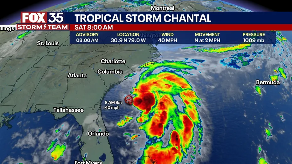
Tropical Storm Chantal emerged from a tropical depression tracked by meteorologists since mid-June 2025, evolving into Tropical Depression 3 on Friday, July 4, and strengthening into a tropical storm by Saturday morning, July 5, as reported by the National Hurricane Center (NHC). Located approximately 150 miles south-southeast of Charleston, South Carolina, at 9 a.m. EDT, Chantal moved slowly north at 2 mph, with maximum sustained winds of 40 mph, according to NHC advisories. This slow movement, coupled with warm ocean waters in the 80s Fahrenheit and the influence of the Gulf Stream, fueled its development, though moderate wind shear and proximity to land prevented rapid intensification, as noted by AccuWeather Lead Hurricane Expert Alex DaSilva.
The storm’s formation exemplifies homegrown development, a phenomenon typical for July, where systems organize close to the U.S. southeast coast, per DaSilva. A frontal boundary stalled off the Atlantic coast, fostering a low-pressure system that evolved into Chantal, as highlighted by Newsweek. By Saturday evening, NHC reported a 70% chance of further strengthening within 48 hours, with winds expected to peak near 50 mph before landfall, per @tropicalupdate on X. The storm’s circular wind field began to stiffen breezes along the Florida to North Carolina coasts, building seas and surf across the region.
Storm Path and Landfall Forecast
Chantal’s projected path indicates a north-northwest trajectory on Saturday, shifting northeast by Sunday night, with landfall expected near South Santee River, South Carolina, around sunrise on July 6, as per Fox Weather. The NHC’s 8 a.m. advisory placed Chantal at latitude 30.9 North, longitude 79.0 West, with tropical-storm-force winds extending 70 miles east of the center. AccuWeather’s forecast map suggests the storm will weaken to a tropical depression by Sunday afternoon as it moves through North Carolina and southeastern Virginia, losing tropical characteristics by Tuesday, July 8.
Hurricane Hunters from the U.S. Air Force conducted flights on Friday, gathering data that confirmed Chantal’s organization, as noted by Newsweek. The storm’s slow pace increases the risk of prolonged rainfall, with 2–4 inches expected across coastal areas, and local amounts up to 6 inches, raising concerns for flash flooding, particularly in northeastern South Carolina and southeastern North Carolina, per NHC’s Storm Total Rainfall Graphic.
Regional Impacts: Heavy Rain, Rip Currents, and Storm Surge
Chantal’s primary impacts include heavy rainfall, life-threatening rip currents, and minor storm surge. Coastal areas from northeastern Florida to the Mid-Atlantic will experience tropical storm conditions starting Saturday afternoon, with tropical storm warnings in effect from South Santee River, South Carolina, to Cape Fear, North Carolina, and a tropical storm watch from Edisto Beach to South Santee River, per NHC. Storm surge is expected to reach 1–3 feet in the warning area and 1–2 feet in the watch area, potentially flooding low-lying coastal zones during high tide, as reported by Yahoo News.
Florida’s Atlantic coast, particularly central and northern regions, faces sporadic showers and thunderstorms, disrupting Independence Day weekend plans, as noted by AccuWeather. Georgia, South Carolina, and North Carolina will see heavy rain, with northeastern South Carolina and southeastern North Carolina at highest risk for flash flooding, per Newsweek. Rip currents, described as life-threatening by NHC, pose significant dangers for beachgoers from Jacksonville, Florida, to the North Carolina Outer Banks, as highlighted by @NHC_Atlantic on X. FOX Weather Storm Specialist Mike Seidel, reporting from Folly Beach, emphasized the storm’s broad center, predicting heavy rain near Charleston by Sunday morning.
Inland areas, particularly the Appalachians, may experience enhanced heat due to the storm’s influence, while tropical downpours could limit heat buildup in the Midwest, per AccuWeather. The storm’s northward movement along the Mid-Atlantic coast early next week may bring gusty winds and cloud cover, mitigating heat in some regions, as noted by DaSilva.
2025 Atlantic Hurricane Season Context
Chantal marks the third named storm of the 2025 Atlantic hurricane season, following Tropical Storm Andrea and Tropical Storm Barry in June. Andrea formed between Bermuda and the Azores, causing no U.S. impacts, while Barry brought 3–6 inches of rain to Veracruz, Mexico, per The Independent. The National Oceanic and Atmospheric Administration (NOAA) forecasts 13–19 named storms, with 6–10 hurricanes and 3–5 major hurricanes, a less chaotic season than 2024’s devastating storms Beryl, Helene, and Milton, as reported by The Independent. Chantal’s early formation aligns with DaSilva’s observation that the season is “several weeks ahead of schedule,” with the third storm typically forming around August 3, per Newsweek.
Saharan dust, dry air, and wind shear in the tropical Atlantic currently limit further development, a common July phenomenon, per DaSilva. Meanwhile, the eastern Pacific is active, with Hurricane Flossie reaching Category 3 status and the next system, potentially named Gil, forming soon, as per AccuWeather.
Safety Measures and Emergency Response
South Carolina Governor Henry McMaster urged residents to monitor forecasts via @SCEMD on X, emphasizing preparedness for Chantal’s impacts during the Independence Day weekend, as noted in a Friday post. NHC and local emergency management agencies are issuing frequent advisories, with U.S. Air Force crews collecting data to refine forecasts, per Newsweek. Tropical storm warnings advise residents to secure outdoor objects, avoid coastal waters due to rip currents, and prepare for flash flooding, particularly in low-lying areas. Storm surge precautions include elevating valuables and following evacuation orders if issued, as highlighted by Fox Weather.
Beachgoers are warned to avoid swimming due to **life-threatening rip “
currents**, with NHC’s rip current risk map indicating high hazards along the Southeast coast, per Yahoo News. Boaters should exercise caution as seas build from Florida to the North Carolina Outer Banks, with wave heights potentially reaching 6–10 feet, as per AccuWeather. Emergency shelters are on standby in Charleston and Wilmington, with local authorities distributing sandbags to mitigate flooding, as reported by Pennlive.
Environmental Factors Influencing Chantal
Chantal’s development is supported by warm ocean waters in the 80s Fahrenheit, bolstered by the Gulf Stream, which continuously feeds warm water to the system, per AccuWeather. However, moderate wind shear and proximity to land limit explosive growth, preventing Chantal from reaching hurricane strength, as noted by DaSilva. Saharan dust and dry air across the tropical Atlantic further suppress development elsewhere, a typical July pattern, per Newsweek. The stalled frontal boundary off the southeast U.S. provided the initial spark for Chantal’s formation, with barometric pressure falling as the system organized, per AccuWeather.
Live Updates and Tracking Resources
NHC’s Advisory 4 at 11 a.m. EDT on July 5 reported Chantal’s winds peaking at 50 mph, with tropical storm conditions expected in South Carolina by Saturday afternoon, per @NHC_Atlantic on X. AccuWeather’s Hurricane Center provides real-time tracking maps, sea temperature data, and storm surge forecasts, accessible via their website and app. Weather Underground offers 5-day forecasts, satellite imagery, and spaghetti models, though NHC relies on the top-performing models for accuracy, as noted by Yahoo News. Fox Weather’s live coverage, featuring Mike Seidel, provides on-the-ground updates from Folly Beach, while The Weather Channel’s storm tracker details Chantal’s path, per weather.com.
Fans can access live updates on NHC’s hurricanes.gov, with Storm Total Rainfall Graphics and rip current risk maps available for detailed planning. AccuWeather’s Premium+ app offers hyperlocal severe weather alerts, ensuring safety for residents and visitors, as per AccuWeather. @weatherchannel on X confirmed Chantal’s formation, urging coastal communities to stay vigilant.
Historical Context and Naming
Chantal is the third named storm of the 2025 season, following Andrea and Barry, and marks the first to directly impact the U.S., as noted by CNN. The name Chantal was previously used in 2019 for a non-impactful Atlantic storm, per Weather Underground. The 2025 Atlantic hurricane season names progress to Gil next, with NOAA predicting an active season driven by warmer-than-normal ocean waters, though less severe than 2024, per The Independent. Chantal’s early formation aligns with homegrown systems common in July, as per DaSilva.
Future Outlook and Regional Preparedness
As Chantal approaches South Carolina, emergency management teams are mobilizing, with tropical storm warnings extended to Cape Fear, North Carolina, per NHC. The storm is expected to weaken to a tropical depression by Sunday afternoon, moving through North Carolina and Virginia before dissipating, as per AccuWeather. Heavy rainfall remains the primary concern, with 2–4 inches expected and local amounts up to 6 inches, potentially causing flash flooding in coastal Carolinas, per NHC. Rip currents and rough surf will persist through Monday, posing risks for beachgoers, as noted by Fox Weather.
Charleston and Wilmington residents are advised to monitor NHC advisories and local emergency alerts, with sandbags and evacuation plans in place for low-lying areas, per Pennlive. Boaters should avoid Atlantic waters, and travelers are urged to check weather updates before heading to coastal destinations, as highlighted by @SCEMD on X.
Navigating Chantal’s Impact
Tropical Storm Chantal, formed on July 5, 2025, brings heavy rainfall, life-threatening rip currents, and minor storm surge to the Southeast U.S., with landfall expected near Charleston, South Carolina, on Sunday morning, July 6. As the third named storm of the 2025 Atlantic hurricane season, Chantal’s slow movement and homegrown development underscore its significance, with 2–4 inches of rain and gusty winds impacting Florida, Georgia, South Carolina, and North Carolina. Residents can stay informed via NHC, AccuWeather, and @NHC_Atlantic on X, ensuring preparedness for this Independence Day weekend storm. Chantal’s trajectory and impacts highlight the importance of vigilance as the hurricane season progresses.


