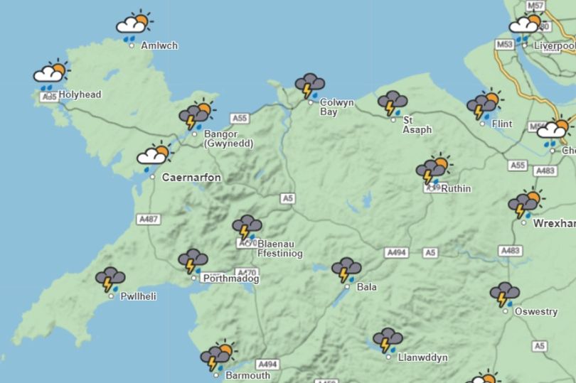
Seven hours of thunderstorms have been forecast to hit North Wales tomorrow (Saturday). Met Office maps show storms are set to start rolling in across northwest Wales at around 8 am.
The maps then show storms across the region throughout the day, with the east affected more at 2 pm until the thunder and lightning are forecast to stop at around 5 pm. There will also be rain showers across parts of North Wales throughout tomorrow and Sunday, although Sunday is predicted to have some cloud and sunny spells following the storms.
The forecasts were based on Met Office maps on Friday morning, which are subject to change. It comes after a yellow alert was issued today for northwest Wales, with people urged to take care amid strong winds, especially in the hills and along the coastline.
Met Office chief meteorologist, Paul Gundersen, said: “Strong winds will develop across the South West early on Friday, pushing further north across parts of Wales through the day. Gusts of 35 to 45 mph are likely quite wide for a time, with gusts over 50 mph affecting some coasts and hills, mainly across Cornwall and west Wales.
“This is an unusual time of year for such strong winds and, with many people on holiday or planning outdoor activities, they are likely to cause some disruption. In addition, heavy rain could lead to standing water and spray on roads and consequently difficult driving conditions. Winds are expected to ease through the evening.
“Temperatures are expected to stay near average or rather cool over the coming days, especially in the rain and wind.”
The warning started at 7 am and lasts until 7 pm on Friday:
Here is the Met Office forecast for Wales for the weekend:
Today:
Winds quickly strengthen during the morning with gales possible on exposed southern coasts for a time. Some heavy and persistent rain during the morning although becoming more showery later. Maximum temperature 20C.
Tonight:
Rain gradually eased through the evening, becoming drier overnight with clear spells. A few isolated showers developed through the early hours of Saturday. Winds easing slightly overnight. Minimum temperature 12C.
Saturday:
Staying unsettled on Saturday with heavy showers and some locally torrential downpours and a risk of thunderstorms. Remaining windy, particularly at the coasts during the afternoon. Feeling cool for July. Maximum temperature 20C.
Outlook for Sunday to Tuesday:
Fewer showers on Sunday, and into the start of next week, with lengthier sunny spells. Winds easing through Sunday and temperatures are around average for July.


